Planning your Camino route
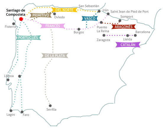
The first step in the planning process is deciding where to go. Of the many different route options, which route will you take? This map illustrates the 12 main waymarked routes, some of which are described in detail on my Route Reports page.

This map below shows the six most popular Camino routes according to the 2015 statistics from the Pilgrim Office in Santiago, Spain.

Label Notes: “Northern” is Camino del Norte and “Original” is Camino Primitivo
The Camino Francés or The French Way is the best known and most traveled of the routes in Spain. Starting in Saint Jean Pied de Port on the French side of the border, this 774 kilometer (480 miles) route begins with a strenuous hike that crosses the Pyrenees Mountains, then descends into rolling hills of the Rioja wine region, continues through the Meseta’s high flat plains, into Montes de León, over the high pass of O Cebreiro, and traverses the many river valleys into the province of Galicia.1
The second most popular route is the Camino Portugués, Most pilgrims start in Porto, but many also walk the 620 km (385 miles) from Lisbon to Santiago. The last 150 km of the Camino Portugués Central route is the one I decided to do in May 2016 (see My Camino Portugués stages.)
The Camino del Norte, also known as the Coastal or Northern Route, originates in the Basque coastal town of Irún on the Spanish-French border. With a distance of 825 km (512 miles), the Camino del Norte has many ascents and descents as it crosses the rivers and rugged Spanish coast, making it slightly longer and more difficult than the Camino Francés.
The Camino Primitivo spans 322 km (200 miles) and begins in Oviedo, the capital of the Asturias region. The Camino Primitivo originated when Moslem occupation of Spain extended northward sufficiently to threaten the traditional Camino Francés route.2

The Coastal Route passes through the lovely Basque resort town of Donostia or San Sebastián. Photo taken October 2014.
The Camino Mozárabe /Via de la Plata or The Silver Route is by far the longest route at 1,000 kilometers (621 miles) and crosses the whole of Spain from Andalucia in the South to Galicia in the North. Once a Roman causeway running between south and north Spain, the Silver Route crosses a more varied terrain than the Camino Francés and is also less frequented.3 As early as the 10th century, Christians living under Muslim rule in the south of Spain were allowed to travel to Santiago de Compostela along the Via de la Plata. According to the Walk the Camino website, it is much less busy than the Camino Frances and is ideal to witness a rural Spain still largely unchanged by modern times.4
Lodging for pilgrims is plentiful along the major routes, with sleeping accommodations of all types—pilgrim albergues or refugios operated by associations and governmental units and as private businesses, hostales, small hotels and several high-end hotels in the Spanish government’s Parador system. An albergue operates essentially like a youth hostel with basic overnight facilities. Most have dormitory-type sleeping arrangements, usually two-tiered bunks, and communal bathing and toilet facilities.
Albergues typically have a set price per night of 6 to 10 euros, while others are donation-based. For additional fees, many albergues and hostales offer private rooms and serve meals. Some pilgrims on a tight budget choose to “rough it” and camp with sleeping bags and tents. Others may be more comfortable staying at three-star hotels and even at the Paradores – some of which offer discounts to pilgrims and special menus (see Pilgrim Lunch at the Parador.) Among all the routes, the Camino Francés has the most highly developed infrastructure, with lodging and facilities about every 10 kilometers.5
According to American Pilgrims on the Camino (APOC), on the less popular routes, there are an increasing number of pilgrim-oriented facilities, some of which have sparse accommodations, like a sport hall or parish room with a spot on the floor and roof over your head. In addition, restaurants along the Camino routes have special discounts such as menú del peregrino or pilgrim’s menu. The style of the pilgrimage can range from inexpensive to luxurious, or a combination of both, depending on how you choose to customize your own Camino. There are many guidebooks, maps, mobile Apps and websites that will assist in planning prior to, and during your journey, as well as nationwide and local organizations that hold events for pilgrims to gather together.
Peregrinos, how did you select your route?
Up next, choose your route stage and time of year to walk your Camino – Part 3 of this series.
References:
1. Camino del Norte. General Description. American Pilgrims on the Camino (APOC).
2. Camino del Norte. Terrain. American Pilgrims on the Camino (APOC).
3. Vía de la Plata (Sevilla). American Pilgrims on the Camino (APOC).
4. Via de la Plata – Silver Route. Walk the Camino.
5. Camino Francés. Accommodation. American Pilgrims on the Camino (APOC).

You are missing the Caminho Português… Sorry, Big mistake!
LikeLike
Hi Mario,
I am actually planning to do part of the Caminho Portugues next year, after talking to peregrinos who highly recommended it. The map in this post was focused on the Spain routes because I had to narrow the focus for a research paper. I know there are many more routes, and I look forward to Portugal next year. 🙂
LikeLike